
Imagine waking up to find a team of surveyors planting concrete markers right across the edge of your agricultural land, mapping out a massive, ultra-modern highway that connects your quiet neighborhood directly to the borders of Delhi and Nepal. For the residents of Seohara, Dhampur, and Nehtaur in Bijnor, Uttar Pradesh, this isn’t a hypothetical situation. It is their current reality.
The mega infrastructure landscape of Uttar Pradesh is shifting yet again. The physical ground team deployment and land marking process for the highly anticipated Gorakhpur Shamli Expressway have officially commenced in the Bijnor district. This greenfield mega-corridor is designed to slash cross-state travel times, open up industrial blind spots, and unlock unprecedented commercial value for smart property buyers.
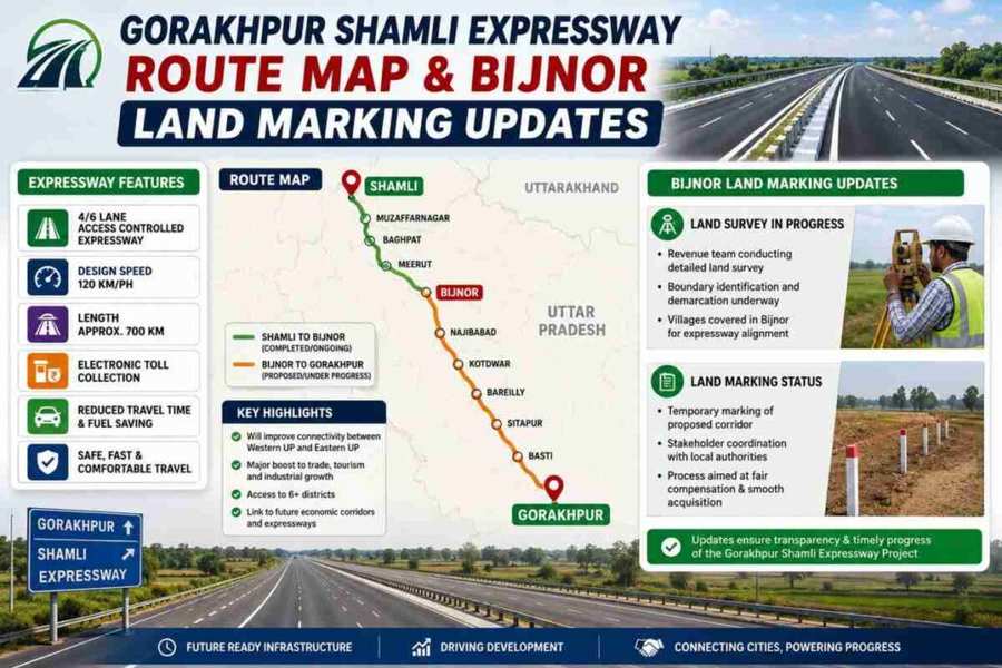
If you are a land investor, business owner, or a regional resident tracking local growth, understanding this massive project isn’t just about reading a map—it is about timing a market cycle before property valuations soar. Let’s dive deep into the specific route maps, the latest physical construction milestones, regional land valuations, and structural timelines that define India’s next major transit artery.
What is the Gorakhpur Shamli Expressway?
A Simple Explanation
The Gorakhpur Shamli Expressway is a planned, 750-kilometer-long, high-speed, access-controlled greenfield highway system being developed under the regulatory stewardship of the National Highways Authority of India (NHAI). Unlike regular highway widening projects that try to patch over existing, congested city streets, a “greenfield” expressway is built completely from scratch over entirely new land parcels. This ensures straight alignments, minimal localized congestion, zero sharp, unsafe curves, and a uniform right-of-way width of approximately 150 meters to easily absorb multi-lane expansion requirements over the coming decades.
The corridor acts as a massive transit arc slicing across the upper and central geographic belts of Uttar Pradesh. It begins near the Nepal border environment in the eastern hub of Gorakhpur and spans across the heart of the state to terminate in the western border town of Shamli, positioned right near the Haryana-Delhi NCR border.
Why It Matters Now
As we navigate through the infrastructure growth cycles, this corridor addresses a major logistical problem: the historical East-West economic divide of Uttar Pradesh. Moving heavy goods or driving from Gorakhpur to the western industrial towns currently requires an exhausting, 12-to-14-hour journey through mixed highway networks and bottlenecks.
By facilitating a design speed limit of up to 120 km/h, the expressway will reduce this massive commute to just about 6 to 8 hours. Furthermore, by intersecting directly with the Delhi-Dehradun Expressway grid in Shamli, it establishes an ultra-fast logistics link between the agrarian hubs of Eastern UP, the manufacturing zones of Western UP, and the massive consumption markets of Delhi-NCR and Uttarakhand.
Key Features and Design Highlights
Building a 750-kilometer-long expressway involves specialized design considerations. NHAI and regional planners have optimized the alignment around three distinct engineering structural pillars:
- 150-Meter Right of Way (RoW): This expansive corridor layout ensures the government secures all required land parcels for future upgrades upfront. While it will initially launch as a highly optimized multi-lane configuration, the massive lateral space allows for seamless lane additions and dedicated service corridors without needing secondary land acquisition phases.
- Integrated Multi-Expressway Intersections: The transit network serves as an architectural shortcut by integrating seamlessly with the Ganga Expressway, Purvanchal Expressway, and the Delhi-Meerut Corridor. This allows a commercial vehicle to shift from one major state artery to another without ever exiting into gridlocked municipal roads.
- Green Logistics Parks and Industrial Alignment: Rather than just creating a high-speed bypass, the Uttar Pradesh Expressways Industrial Development Authority (UPEIDA) is working parallel to the project to inspect and clear dedicated land segments adjacent to the highway to establish localized industrial manufacturing clusters.
Structural Benefits of the Expressway
+--------------------------------------------------------------------------+
|                       THE TRIPLE-BENEFIT LIFECYCLE                       |
+-----------------------------------+--------------------------------------+
| FINANCIAL IMPACT                  | REGIONAL LOGISTICS                   |
| • 3x to 4x surge in land value   | • Travel times cut from 14 to 7 hours |
| • Direct electronic compensation  | • Bypasses crowded urban centers    |
+-----------------------------------+--------------------------------------+
|                       FUTURE ECONOMIC GROWTH                             |
| • Integrated UPEIDA Industrial Nodes & Green Manufacturing Hubs          |
+--------------------------------------------------------------------------+
Financial Benefits
For real estate investors, the immediate benefit lies in capital appreciation along the alignment. Agricultural land blocks that previously had minimal commercial utility due to poor road connectivity are witnessing instant re-classification. Historical trends from the Purvanchal and Yamuna Expressways show that early-stage land marking routinely triggers a 3x to 4x surge in land valuations over a 3-to-5-year horizon as commercial zoning applications are filed.
Lifestyle and Business Benefits
Local freight operators and agribusinesses gain the ability to transport perishable items—such as sugarcane crops from Bijnor or fresh agrarian goods from eastern districts—to major urban storage centers without catastrophic delays. The reduction in wear-and-tear on commercial fleets and lower fuel consumption drastically optimizes supply chain economics for small and medium enterprises (SMEs) operating within central UP.
Long-Term Value
This corridor secures long-term value by transforming remote regional towns into sustainable transit nodes. By laying down extensive industrial infrastructure along a modern highway system, the state is effectively creating counter-magnets to the overcrowded Delhi-NCR zone, encouraging balanced manufacturing investments deep into the interior districts of Rohelkhand and Purvanchal.
Location and Detailed Market Analysis: Bijnor Focus
The real estate narrative has shifted to the Bijnor district, where NHAI field teams have deployed to execute physical ground land marking.
The Ground Reality in Bijnor
The land demarcation process is moving forward rapidly in the Seohara block, with teams targeting agricultural stretches within key villages including Nichalpur and Milak. Field crews are actively surveying plot boundaries, correlating them with structural land records (Gata numbers), and setting down permanent cement marker poles across a wide path. This physical marking phase provides concrete assurance to property buyers that the project alignment is finalized and locked on the ground.
Beyond Seohara, the alignment is mapped to cut through key clusters within the Dhampur and Nehtaur administrative zones. The local administration, led by regional revenue officers, is simultaneously finishing detailed land asset tracking to prepare for administrative payouts.
Infrastructure and Connectivity Growth
What makes Bijnor an investment zone along this route? It sits at a crucial geographical crossroads where the proposed Gorakhpur Shamli Expressway will intersect near the Meerut-Pauri National Highway (NH-119).
To maximize this asset, UPEIDA has launched extensive land surveys across 10 designated local villages. Six of these village land surveys are fully finalized, with the remaining four in their closing verification phases. This data is being consolidated into an official industrial layout report. The goal is simple: construct a sprawling industrial corridor right at the convergence point of the expressway and NH-119, turning Bijnor from a quiet agricultural zone into a key manufacturing and distribution hub.
Full District Route Breakdown
To understand how this massive project reshapes the connectivity profile of Northern India, let’s look at the complete geographical alignment. The Gorakhpur Shamli Expressway runs across 22 distinct districts and 37 administrative tehsils, bridging five major socioeconomic zones:
| Geographic Belt | Districts Covered Along the Alignment | Key Economic Characteristics |
| Eastern Purvanchal Belt | Gorakhpur, Sant Kabir Nagar, Basti, Gonda | Start of the alignment; heavy link to Nepal border trade and agrarian storage centers. |
| Terai & Central UP Corridor | Ayodhya, Bahraich, Barabanki, Sitapur, Lakhimpur Kheri | Crosses central tourist and sugar production belts; major transit bridges constructed over seasonal rivers. |
| Rohelkhand Hub | Shahjahanpur, Hardoi, Budaun, Bareilly | High-volume industrial and agro-processing zones; Bareilly sector covers more than 60 villages. |
| Moradabad & Western Belt | Moradabad, Sambhal, Amroha, Bijnor | Heavy metal manufacturing, brass handicraft clusters, and massive sugarcane farming zones; site of active land marking. |
| NCR Frontier Region | Meerut, Saharanpur, Muzaffarnagar, Shamli | Terminal sector; directly links to Western manufacturing centers and the Delhi-Dehradun corridor. |
Investment Potential and Practical Use Cases
Investing in real estate adjacent to a multi-thousand-crore greenfield project requires a highly analytical approach. Let’s break down the actual risks, rewards, and profiles driving this market.
ROI Opportunities
The most profitable strategy along this corridor involves acquiring land parcels situated within a 2-to-5-kilometer radius of planned toll plazas, interchanges, and service exits. Land positioned directly along the midsection of a fenced, access-controlled highway has minimal utility if you can’t physically access the road. However, properties near intersections are prime locations for warehouses, private logistics yards, fleet maintenance points, and highway retail plazas.
Risk Factors (A Realistic Assessment)
While the upside is massive, smart investors must remain grounded regarding potential project bottlenecks:
- Acquisition Disputes: While land marking has started smoothly in Bijnor, individual land parcel legal disputes or farmer protests over regional circle rates can cause localized construction delays on specific packages.
- Liquidity Horizon: Greenfield expressways are long-term plays. The projected window for full mainline completion is targeted toward 2030. If you require immediate cash flow or short-term flipping returns, buying raw agricultural land here could tie up your capital for years.
- Strict Zoning Enforcement: With UPEIDA and NHAI strictly controlling the right-of-way boundaries, unauthorized commercial developments or roadside shops without official access permits will face demolition.
Who Should Invest?
This corridor is tailor-made for institutional logistics developers, long-term wealth creators, and agro-commodity businesses seeking to set up processing units close to a reliable, high-speed freight route.
Project Timeline and Lifecycles
Understanding the exact stage of an infrastructure project protects you from overpaying during speculative bubbles. Here is how the development lifecycle is mapped out:
Alignment Approval & Detailed Project Report
Completed Phase
Satellite imagery mapping and drone-based geographical surveys finalized the exact route across all 22 districts. The detailed engineering layout was approved by central planning bodies.
Ground Demarcation & Land Marking
Active Stage (2026)
NHAI field crews are deployed on-ground in Bijnor (Seohara, Nichalpur) and segments of Bareilly. They are setting concrete perimeter markers, recording Gata land parcel numbers, and freezing property title changes along the direct alignment.
Tendering & Civil Package Allocation
Upcoming Phase (Late 2026 – 2027)
The 750 km alignment will be divided into multiple independent civil packages. The government will invite bids from tier-1 infrastructure firms using the Hybrid Annuity Model (HAM) to share financial deployment risks.
Mainline Construction & Structural Engineering
Mid-Term Target (2027 – 2029)
Massive earthworks, deep grading, asphalt paving, and the construction of complex river bridges, overpasses, and local underpasses roll out simultaneously across all packages.
Safety Testing & Public Commissioning
Target Completion (Estimated 2030)
Installation of automated toll systems, safety barriers, solar-powered highway lighting arrays, and final inspection clearance to open the expressway for commercial freight and public vehicle traffic.
Step-by-Step Guide for Safe Land Acquisition Along the Route
If you are planning to purchase real estate along the emerging Gorakhpur Shamli Expressway corridor, do not let excitement bypass proper due diligence. Follow this rigorous step-by-step framework:
1.Verify the Official Alignment Mapping via Gata Numbers:Prerequisite Verification.
Cross-reference the seller’s specific plot numbers with the official land acquisition notifications published by the regional revenue department or NHAI. Ensure the plot sits adjacent to the expressway zone rather than inside the 150-meter acquisition zone, unless your goal is simply collecting government compensation.
2.Extract a Clear 30-Year Land Title History:Legal Title Check.
Work with a localized property attorney to extract the ‘Bhulekh’ (digital land records) and register documents stretching back at least 30 years. Confirm there are no hidden familial disputes, mortgage liabilities with regional cooperative banks, or pending court litigations.
3.Audit the Master Plan and Zoning Clearance:Regulatory Alignment.
Check with the local district town planner to see if the property falls under an area designated for the upcoming UPEIDA industrial corridor, residential expansion, or if it is restricted under strict forest or agrarian conservation zoning laws.
4.Assess Physical and Legal Access Rights:Site Viability Check.
Because greenfield expressways are fully access-controlled, you cannot directly drive onto the highway from your property. Ensure the land parcel has a legally documented link to an official local service lane, state highway, or rural link road that connects back to a designated expressway interchange plaza.
Expert Insider Tips for Property Buyers
- Look Beyond the Immediate Roadside: Do not fixate only on land that touches the highway boundary fence. Look for micro-markets located 3 to 7 kilometers away along connecting state highways. These parcels are significantly cheaper right now and offer superior local access.
- Analyze the Industrial Corridor Overlap: Focus on the Bijnor-Sadar and Seohara intersections where the expressway crosses major existing state roads. Properties here will benefit from institutional demand as manufacturing companies compete for logistics space.
- Verify Regional Circle Rates: Compare the asking price against the official government circle rates. Speculative sellers often mark up prices by 300% the moment land marking poles are planted. Pay for the current reality, not the final 2030 completed valuation.
- Understand the Compensation Dynamics: If you are buying land that faces partial acquisition, remember that under current land acquisition rules, rural land owners typically receive significantly higher payouts relative to registered market values compared to urban zones. However, processing these files takes administrative time.
Common Mistakes to Avoid
⚠️ The “Land-Locked” Trap: Many early buyers mistakenly purchase long, narrow agricultural plots along an upcoming greenfield route, only to find out later that the highway fence cuts off their ancestral access roads. This leaves them with a piece of land they can see from the highway, but cannot physically drive into. Always check how the local service lanes are mapped out before signing a purchase agreement.
- Ignoring Local Waterways: Large stretches of the Terai and central UP regions are prone to seasonal river flooding. Review historical monsoon satellite maps to ensure your chosen investment plot doesn’t turn into a waterlogged swamp during the rainy season.
- Buying on Verbal Assurances: Local brokers frequently use expressions like “the interchange is coming right here” to inflate property prices. Trust only official NHAI geometric design maps and gazette notifications.
Future Spatial Trends (2026–2030)
As construction advances toward the 2030 operational target, expect to see the rise of Smart Logistics Mini-Cities. Rather than traditional highway truck stops, these nodes will feature cold-storage hubs, automated sorting facilities run by private third-party logistics firms, and integrated commercial resting Plazas.
Additionally, the state’s push to run this expressway as a highly sustainable corridor means that land near planned solar array fields and green charging stations will command premium positions for commercial fleet operators.
Summary of Insights
The commencement of physical land marking in the Seohara region of Bijnor marks the transition of the Gorakhpur Shamli Expressway from a conceptual blueprint into a tangible, transformational infrastructure project. Spanning 750 kilometers and touching 22 districts, this greenfield corridor is positioned to reshape the logistical economics of Northern India. While the long-term capital appreciation potential for real estate investors is undeniable, navigating this emerging market requires strict due diligence, legal title validation, and an investment horizon aligned with the 2030 completion timeline.
For residents and businesses across Gurugram, Noida, and Delhi, the message is clear: the days of being hopelessly stuck in traffic are winding down. for Cutting out traffic Govt has launched Delhi katra Expressway It is time to look forward, adapt to these emerging corridors, and position your investments to ride the wave of this historic infrastructure transformation.
You will see a city built for the next generation. Knowledge Park 5 is not just about real estate. It is about the quality of life you deserve. It represents a smart choice for your family and your finances. Take a drive through the sector and see the progress yourself. You will see a city built for the next generation. Sector 4 Greater Noida, is more than just a destination on a map; it represents the modern Indian dream of affordable luxury and planned growth. Knowing the Sector 4 Greater Noida pin code is just the beginning of your journey. Whether you are moving here for work, family, or investment, the area offers a robust foundation for a high-quality life. With its strategic location, improving infrastructure, and vibrant community, Sector 4 is undoubtedly one of the best places to plant your roots in the NCR. for more doubts get a On call free session by Real Estate Advisory or Visit byviveksingh.in to book a direct strategy consultation. Are you a Business Owner ? than For business owners, the primary benefit is the guaranteed footfall. Book your Commercial Shop in Mahagun Metro Mall Today as Being located right near the Vaishali Metro Station means a constant stream of commuters is funnelled toward the mall. High visibility leads to lower customer acquisition costs for retail tenants
Frequently Asked Questions
Which specific districts are covered by the Gorakhpur Shamli Expressway route?
The 750-kilometer expressway connects 22 major districts across Uttar Pradesh. It begins in Gorakhpur and moves through Sant Kabir Nagar, Basti, Gonda, Ayodhya, Bahraich, Barabanki, Sitapur, Lakhimpur Kheri, Shahjahanpur, Hardoi, Budaun, Bareilly, Rampur, Sambhal, Amroha, Moradabad, Bijnor, Meerut, Muzaffarnagar, Saharanpur, and terminates at Shamli near the Delhi-NCR border region.
What is the current status of the project in the Bijnor area?
The project has transitioned into the active on-ground land marking and demarcation stage. NHAI field crews are deploying across the Seohara block, specifically installing permanent concrete markers in villages like Nichalpur and Milak to outline the 150-meter-wide path of the upcoming greenfield highway.
When is the Gorakhpur Shamli Expressway expected to open to the public?
While initial physical surveys, alignment designs, and localized land marking phases are moving ahead smoothly across various packages, the full-scale mainline civil construction timeline is a mid-term endeavor. Planners estimate full project completion and public commissioning by approximately 2030.
How will this new greenfield expressway affect local real estate prices?
Historically, major greenfield expressways in Uttar Pradesh drive a 3x to 4x surge in neighboring land valuations over a 3-to-5-year period. The current land marking in regions like Bijnor is already triggering increased commercial interest, particularly for parcels located close to planned interchanges and upcoming UPEIDA industrial corridors.
Can individuals directly access the expressway from their adjoining fields or private roads?
No. The Gorakhpur Shamli Expressway is engineered as a fully access-controlled highway system. This means entry and exit are strictly limited to designated interchange points and toll plazas. Properties running along the route must rely on localized service lanes built parallel to the highway fence to reach these official access points.