The transformation from quiet agricultural belts to bustling economic hubs rarely happens overnight, but every major project reaches a defining moment where blueprints cross over into reality. For years, the concept of “New Noida”—officially designated as the Dadri-Noida-Ghaziabad Investment Region (DNGIR)—existed primarily on administrative drafts and urban master plan maps. Today, that narrative has shifted completely.
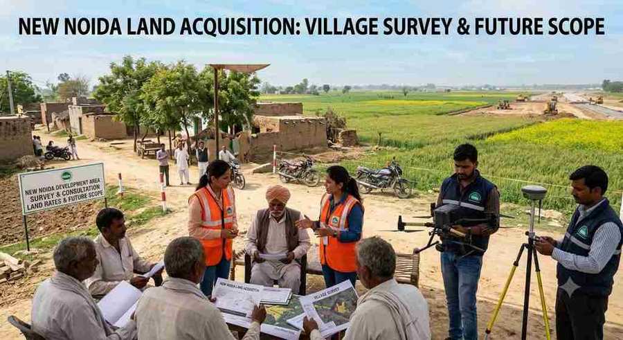
The New Noida land acquisition process has officially moved to the ground. Revenue teams have deployed across the region, commencing rigorous physical and digital surveys across 31 primary villages in the project’s first phase. Officials are meticulously verifying land ownership records, mapping existing abadi (residential) areas, and logging individual parcel boundaries.
For farmers, local landowners, institutional investors, and home-seekers, this transition marks a pivotal turning point. Understanding the mechanics of land acquisition, compensation structures, mutual consent framework, and long-term development plans is critical. This comprehensive guide walks you through every layer of the New Noida development project, offering grounded insights into what is happening, why it matters, and how to navigate the emerging landscape.
What is New Noida Land Acquisition?
Simple Explanation
New Noida land acquisition refers to the legal, administrative, and financial process through which the Noida Authority is securing land to build the Dadri-Noida-Ghaziabad Investment Region (DNGIR). Envisioned as a massive industrial and economic mega-city, New Noida spans over 20,000 hectares across the Gautam Buddha Nagar and Bulandshahr districts of Uttar Pradesh.
Instead of relying solely on compulsory acquisition methods of the past, the Authority is prioritizing direct purchases through mutual consent with local landowners. Revenue teams conduct door-to-door ground verifications, cross-referencing physical holdings with revenue records to ensure seamless transfer, fair compensation, and zero disputes before construction begins.
       New Noida (DNGIR) Phased Land Acquisition Framework
 ┌─────────────────────────────────────────────────────────────┐
 │                     Phase 1 Scope                           │
 │        • 31 Villages Targeted                               │
 │        • ~3,000+ Hectares Initial Acquisition               │
 │        • Direct Mutual Consent Purchases                    │
 └──────────────────────────────┬──────────────────────────────┘
                                │
                                ▼
 ┌─────────────────────────────────────────────────────────────┐
 │                  Verification & Mapping                     │
 │        • Ground Revenue Record Verification                 │
 │        • Satellite GIS & Drone Mapping                      │
 │        • Abadi (Residential) Boundary Freezing              │
 └──────────────────────────────┬──────────────────────────────┘
                                │
                                ▼
 ┌─────────────────────────────────────────────────────────────┐
 │              Compensation & Benefits Package                │
 │        • Direct Financial Compensation                      │
 │        • Developed Abadi Plot Allocations                   │
 │        • Rehabilitation & Resettlement (R&R) Rights       │
 └─────────────────────────────────────────────────────────────┘
Why It Matters in 2026+
As urban centers like Noida and Greater Noida reach structural saturation, regional economic growth requires new territory designed explicitly for modern industrial, logistical, and commercial needs. New Noida fills this gap by acting as a link between major national freight corridors.
The initiative is directly tied to the Western Dedicated Freight Corridor (WDFC) and the Eastern Dedicated Freight Corridor (EDFC). The timing is critical: with multi-modal logistics hubs coming online, the region requires scalable land to host heavy manufacturing, semiconductor units, logistics parks, and high-density residential sectors over the coming decades.
Key Features & Highlights of the Acquisition Plan
Feature 1: Dual-Layer Verification (Ground + Satellite)
To eliminate land fraud, modern encroachments, and false claims, the acquisition framework relies on a hybrid verification methodology. While revenue officials conduct physical ground surveys across the 31 phase-one villages, high-resolution satellite imagery and GIS mapping run concurrently. This dual-layer check helps the Authority track historical land usage, identify illegal constructions erected to claim higher compensation, and freeze existing abadi zones accurately.
Feature 2: Acquisition via Mutual Consent
Rather than enforcing lengthy acquisition procedures, the government is placing primary emphasis on mutual consent transactions. Landowners negotiate directly with designated authority committees based on fixed, transparent rates. This process accelerates land transfer, minimizes legal battles, and ensures that funds are directly deposited into verified bank accounts without prolonged administrative delays.
Feature 3: Differentiated Compensation and Plot Rehabilitation
The compensation model is designed to support the local agrarian community’s transition into an urbanized economy. In addition to monetary payout per square meter, eligible farmers receive developed land plots (typically a designated percentage of their acquired holding) within planned abadi-rehabilitation sectors. These developed plots allow local families to retain physical real estate in what will become prime urban land.
Benefits of New Noida Land Acquisition
Financial Benefits
For local landholders, the structured acquisition provides immediate liquidity at fair market-aligned rates. Beyond cash payouts, holding developed rehabilitation plots offers long-term financial security. Historically, original landowners in early Noida and Greater Noida phases who retained their developed residential plots saw their net worth multiply substantially as surrounding sectors commercialized.
Lifestyle and Business Benefits
The acquisition sets the stage for planned urban living. Unlike unplanned urban expansions, New Noida Master Plan 2041 incorporates:
- Wide sector roads and green buffer zones.
- Dedicated industrial nodes away from residential clusters.
- Integrated underground utility corridors for uninterrupted power, water, and fiber-optic communication.
- World-class civic infrastructure including healthcare facilities, educational zones, and public parks.
Long-Term Regional Value
By systematically acquiring land ahead of major construction, the government prevents haphazard development. This structured approach builds investor confidence, encouraging multinational corporations, logistics giants, and manufacturing entities to establish operations in the zone, creating thousands of local jobs and driving sustained economic growth.
Location & Market Analysis
                  ┌──────────────────────────────┐
                  │    Noida International       │
                  │       Airport (YIDA)         │
                  └──────────────┬───────────────┘
                                 │
                                 ▼
┌──────────────────┐   ┌──────────────────┐   ┌──────────────────┐
│   Noida-Greater  │───│    NEW NOIDA     │───│ Dedicated Freight│
│   Noida Express  │   │  (31 Phase 1     │   │ Corridors (WDFC/ │
│                  │   │   Villages)      │   │     EDFC)        │
└──────────────────┘   └──────────────────┘   └──────────────────┘
                                 ▲
                                 │
                  ┌──────────────┴───────────────┐
                  │ Integrated Industrial Town   │
                  │        & Eastern Peripheral  │
                  └──────────────────────────────┘
Connectivity Breakdown
The geographical positioning of the 31 phase-one villages makes New Noida one of the most strategically located industrial nodes in Northern India:
- Road Network: Directly connected to the Eastern Peripheral Expressway (EPE) and the Grand Trunk (GT) Road.
- Rail Corridors: Adjacent to the Dadri Railway Junction, serving as the crucial intersection point for Eastern and Western Freight Corridors.
- Air Connectivity: Situated within convenient driving distance of the Noida International Airport at Jewar.
Infrastructure Growth Potential
The master plan allocates significant land area specifically for industrial and logistical use (over 40%), while residential, commercial, and green spaces make up the remainder. The spatial distribution ensures that industrial traffic bypasses residential zones entirely, maintaining clean air and smooth traffic flow across the city.
Investment Potential & Use Cases
ROI Opportunities
The rollout of land acquisition historically marks the entry phase of the real estate value curve. Early-stage development—where land is verified, acquired, and handed over for infrastructure development—typically precedes significant land value appreciation. Investors targeting commercial, warehouse, or peripheral residential markets around the DNGIR region stand to gain as the primary infrastructure takes shape over the next 5 to 10 years.
Land Value
  ▲
  │                                           / [Mature City Stage]
  │                                          /
  │                                 /───────┘
  │                                / [Infrastructure Buildout]
  │                       /───────┘
  │                      / [Acquisition & Survey Stage - CURRENT]
  │             /───────┘
  │            / [Planning & Map Stage]
  └───────────┴─────────────────────────────────────────────► Time
Risk Factors to Consider (Honest Evaluation)
While the long-term outlook is promising, every major land development project carries inherent risks:
- Timeline Variances: Ground verifications, title clearance, and mutual consent negotiations can experience delays due to local ownership disputes or boundary rectifications.
- Proximity to Construction: Early peripheral developments may lack immediate civic amenities like schools, market complexes, and operational public transit for several years during the buildout phase.
- Litigation Risks: Agricultural land outside the formal Authority acquisition framework may carry encumbrances, overlapping titles, or legal stays.
Who Should Invest / Participate?
- Local Landowners: Those whose land falls under the acquisition zone should ensure their revenue titles (Khatauni/Khasra) are updated to guarantee frictionless payouts and plot allocations.
- Long-Term Investors: Capital patience is required; those looking for capital growth over a 7-to-10-year horizon will find the industrial corridor’s trajectory compelling.
- Industrial & Logistics Operators: Businesses requiring large-format warehousing near freight corridors should track Authority land allotment auctions following the completion of the acquisition phase.
Step-by-Step Guide for Landowners and Stakeholders
1.Title & Revenue Record Verification:Prerequisite Step.
Verify that your revenue entries (Khatauni) match physical land possessions. Any discrepancies in co-ownership shares or name spellings should be rectified at the local Tehsil office immediately.
2.Ground Survey & GIS Identification:Official Field Assessment.
Cooperate with visiting revenue teams and Authority surveyors. Ensure your existing residential structures (abadi) are documented during the physical survey and captured accurately on satellite maps.
3.Objection Submission & Compensation Agreement:Mutual Consent Negotiation.
Review the formal notification issued by the Authority regarding acquired land parcels. Submit any boundary or title objections within the stipulated timeframe before signing the mutual consent agreement.
4.Document Execution & Direct Payout:Financial Settlement.
Execute the legal transfer deed. Once verified, monetary compensation is transferred directly to the owner’s bank account, and certificates for developed abadi-plot entitlements are issued.
Expert Practical Advice for Navigating Acquisition
- Keep Land Records Updated: Ensure all joint family shares are clearly documented in the official revenue registers (Khatauni) before the final survey sign-off.
- Verify Boundaries Physical vs. Digital: Confirm that the physical possession lines match the GIS mapping records utilized by the survey teams.
- Maintain Clear Structural Evidence: Keep documented proof (photographs, utility connections) for pre-existing residential houses within village abadi limits to safeguard your residential plot rights.
- Avoid Fresh Unsanctioned Construction: Do not construct temporary structures on agricultural land solely to claim extra compensation; satellite tracking identifies recent structures built after notification dates.
- Consult Authorized Channels Only: Rely exclusively on official notifications published by the Noida/New Noida Authority rather than unverified local rumor networks.
Common Mistakes to Avoid
| Common Mistake | Immediate Impact | How to Prevent It |
| Ignoring Minor Record Discrepancies | Delayed compensation payouts during title verification. | Reconcile name spellings and co-ownership percentages at the Tehsil early. |
| Buying Unnotified Land in Survey Zones | Potential financial loss if land is acquired at base rates or frozen. | Cross-check Master Plan 2041 zoning maps before purchasing peripheral land. |
| Encouraging Unsanctioned Abadi Expansion | Rejection of compensation claims due to satellite imagery tracking. | Avoid fresh illegal construction once survey notifications are issued. |
| Failing to Track Phase-Specific Guidelines | Missing deadlines for submitting objections or consent forms. | Regularly review official Authority press releases and village notice boards. |
Future Outlook (2026–2030)
Between 2026 and 2030, New Noida will transition from ground acquisition into primary infrastructure buildout. As phase-one land in the 31 villages is handed over to the Authority:
- Road & Utility Networks: Trunk infrastructure, broad sector roads, and electrical grid layouts will take shape.
- Industrial Allotments: Major manufacturing, logistics, and technology firms will receive land allotments to build operational facilities.
- Rehabilitation Sector Development: Developed residential sectors dedicated to original landholders will be fully integrated with municipal services.
- Economic Integration: The operational synergy between the Jewar International Airport, the Western Freight Corridor, and New Noida will solidify the region as a primary industrial engine in Northern India.
Conclusion
The onset of physical surveys across the initial 31 villages demonstrates that New Noida is progressing from a master plan vision into an active urban reality. For landowners, the emphasis on direct mutual consent offers a transparent path toward fair financial realization and long-term asset retention through developed plot allocations. For regional investors and industrial players, the emerging corridor presents a major growth opportunity anchored by freight infrastructure and planned development. Staying informed, maintaining clear documentation, and adhering to official guidelines remain the best practices for everyone involved in this transformational journey.
For investors seeking a balance of consistent rental income and strong future capital appreciation, the Cyber Arch IT Park Studio Apartment Greater Noida offers an undeniable opportunity. Its location is a magnet for the corporate and student population, locking in long-term demand. Now is the opportune moment to conduct final due diligence and secure your stake in the future of Greater Noida West. Invest in a Cyber Arch IT Park Studio Apartment Greater Noida today and position your portfolio for exponential growth.
Frequently Asked Questions
What is the current status of New Noida land acquisition?
Ground surveys and revenue record verifications have commenced across 31 phase-one villages. Teams are cross-referencing physical land holdings with satellite imagery and Khatauni records to prepare for mutual consent purchases.
How many villages are included in the first phase of New Noida?
The first phase focuses on 31 primary villages located across Gautam Buddha Nagar and Bulandshahr districts out of the total proposed 80+ villages in the complete Master Plan 2041.
How will farmers and landowners be compensated?
Landowners receive monetary compensation based on mutually agreed rates per square meter, along with allocations of developed residential (abadi) plots in planned rehabilitation sectors as per prevailing Authority guidelines.
What is the role of satellite imagery in the land survey?
Satellite and GIS mapping track existing land usage, verify old residential (abadi) boundaries, and detect illegal or fresh constructions erected after acquisition announcements, ensuring accurate compensation distribution.
When will industrial development begin in New Noida?
Phase-one industrial allotment and trunk infrastructure construction will commence progressively as land parcels within the initial 31 villages are acquired and handed over to the Authority.